


Location: Desolation Wilderness – Lake Tahoe, CA
Duration: 3 – 4 hours
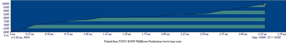
Elevation Change: 3,806′ – from 6,177′ to 9,983′
Recomended Map: Pyramid Peak Trailhead, California
Elevation Profile:
Map of General Route:
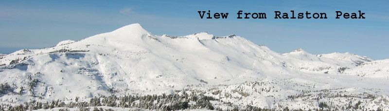
When viewed from Sierra-at-Tahoe ski area or the summit of Mt. Tallac, this bald beauty at the south end of the Desolation Wilderness will likely become your next goal. Got a 4000′ climb in you? It will feel easier going up and harder coming back, as the snow gets too soft in the afternoon down low. Park near Horsetail Falls on Highway 50, where there is no wintertime designated parking. Please ask Eldorado County why both sides of the highway have endless room to park, with NO PARKING signs everywhere. They are probably trying to avoide a huge sledding and snowplay area forming. Leave a note on your car that says “I know what I’m doing and skiing Pyramid Peak! I need the car to be here when I get back!”. I haven’t heard of anyone receiving a ticket here. But I don’t know many people who have even done this ski tour either.
The approach down low often looks too thinly covered, but deep snow-pack and firmer snow is gauranteed 500′ above your car. Getting up or down that 500′ south facing slope can be dangerous in the typical warm weather at 6000′ in the sun. Stay out of the Horsetail Falls drainage going and coming as well. The terrain is steep and suspetable to wet slide conditions. Basically, if you can easily push your ski pole basket straight through spring corn snow more than a few inches, you need to get off that slope. You can also access the peak from Aloha Lake in an unforgettable overnight Desolation Wilderness tour coming in from Echo Lake or in a north to south route from Bayview Trailhead. I’ll post some pics form that tour I did last year with a small crew form the shop.
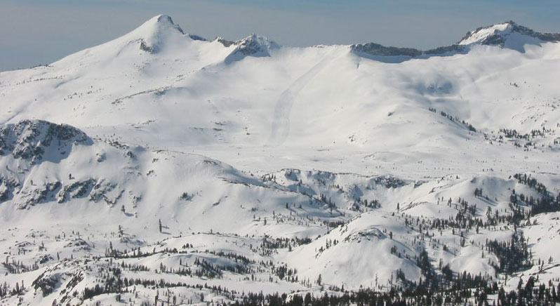
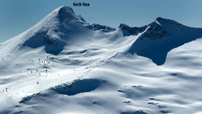
Pyramid Peak looks un-skiable from most all vantage points because it’s so far away, especially the north slope. The North and East slopes beneath the summit are about 40 degrees steep for 1000′. I’ve skied the north side once ,but my perception is that it is usually wind hardened most of the time, and small rocks pepper the slope even in a big winter. Go for it just to point and brag to your friends from the north. There is no cornice at the top and you can look straight down. Don’t slide off or drop a ski up there, it’s firm snow and a cozy small bald round summit.
The south and SE sides of the summit get a lot of wind too, and it’s not going to be very smooth up there. Skiing Pyramid Peak is more of a tick list adventure and a day with no other people. Splitboarding isn’t going to be great on the lower half going up or down, due to traversing and flat terrain in the middle, and unconsolidated mank down low. But what else do you have to do? Go for it! Pyramid is the highest Peak in Desolation Wilderness.
Avalanches hazards and ski conditions are hard to predict in high, windy, treeless areas like this. Just take the south side back home if you’re unsure. When conditions are right, a beautiful 2000’ east-facing bowl begs you to ski down to Gefo and Toem Lakes. You won’t notice any lakes; these small guys are buried. If you end up way down here, be sure to avoid Horsetail Falls Drainage and traverse back to the ascent route. If you ski the south slope off of Pyramid, you are not near this terrain trap and will enjoy more open terrain for turning on the way back to your car.
I’ve heard of skiers climbing and descending Pyramid Peak from hwy 50 in the Rocky Canyon drainage, seen on my map. I haven’t tried this because it puts the start a little lower in elevation. You do get better snow coverage and firmness down low however, due to the west facing side of this drainage. Maybe next time. I came out of there on my last multi day tour across Desolation, and found a user created summer trail. That was certainly the ticket to getting out when there is zero snow for the final 1000′.
One last note. Since the fire of 2021 has left the lowest south facing slope above hwy 50 totally bare of trees, it may be much easier to get through now without the huge manzanita bushes.

Looking for awesome ski and splitboard tours in the Sierras? We’ve got write ups on many common and uncommon tours curated by the owner of the BackCountry, Mike Schwartz.


On 3/14/17 I went up Pyramid Peak again with Paul from our shop The BackCountry. It has been warm and didn’t freeze, so the initial 500′ was unconsolidated and borderline ready to give way. We hurried through there knowing we would have to deal with it again on the return. As expected, the snow got firm as soon as we cleared the first hill. A welcome wind kept the snow firm for a fast climb up to the summit, 4000′ from hwy 50 at Horsetail Falls.
You could have parked 100 cars on the highway down there, but signs everywhere say no parking. Call El Dorado County and ask for skier parking. We want winter access to our public lands just like we have in the summer. There was a CHP officer hanging out in a car who said he wasn’t going to ticket us. I doubt you would get a ticket on a sunny day in this location.
We skied the east side down to the low angle, and traversed out right and kept going to near the head of Horsetail Falls. We found steep benchy cliffs to weave through in some beautiful terrain. It took some careful scouting on the way down to stay clear of steep rollovers that could possibly fail due to the very warm temps. It hadn’t snowed in a week, and avy danger was nil…but there is that moment where slope angle and warm temperature briefly change their attitude on you.
Getting out along the side of the Horsetail Falls Drainaige would be a breeze with firm snow. We had sloppy wet slide potential conditions. We could have skinned back up to the ridge, but instead just found the right path and snow. I feel like this is pretty typical conditions to ski Pyramid Peak. It’s going to be warm and falling apart in afternoon down low on S and E slopes below 7k. You park at 6k for this tour.
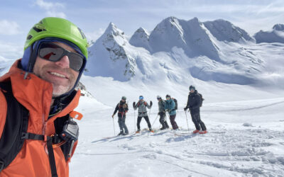
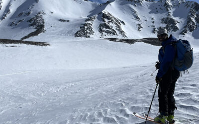
Here are some pics from an amazing 3 day tour from Bayview Trailhead to hwy 50. I took some of my staff in spring of 2021 and we crossed the Dicks high col to Jack’s Peak. We skied that west slope in late afternoon in great corn dune to our camp at Mosquito Pass. The next day we summited Price and did a wild exploratory loop off the West side, returning to the same camp just as the sun went down. And on the 3rd day we skied across Aloha and summited Pyramid. We skied the south slope down to about 7000’ into Rocky Creek. I found the summer use trail on the east side of the drainage and we stepped over down trees and suffered the steep dirt walk in ski boots with big packs.