
Hi, I’m Mike, and I started The BackCountry shop in 1994.
I want to thank you for helping us stay alive at our retail shop. You are supporting the families of over 30 employees as well as many local gear reps who we buy from.
This ski touring blog is in constant edit and add mode. I re-write nearly every time I look at my posts honestly. Check back regularly for improvements. Please don’t take anything I’ve said with 100% accuracy. My process is simply based on memory and looking at pictures I take. There is no precise measuring or complicated computer mapping going on here. I might start GPS tracking however with Gaia, replacing my old silly maps. Stop by the shop or contact me directly for help planning your ski tours. I am happy to direct you to the many local pro IFMGA guides as well.
There is an absurdity in trying to describe a backcountry ski tour. There is way too much to say if I were aiming to warn you of every danger and explain how to find the best experience. I buy every guidebook for ski touring and rock climbing, and rarely find I needed the few sentences I read. But they got me in the car and pointed me towards the best stuff in the area. My main goal is to get people stoked on ski touring while I tap at a keyboard at 3am, looking over old photos.
You can now add a comment with pictures and tell us about you day or recommend how I should edit my posts. I will read it all and I really appreciate your participation! I may not publish every comment. Think about contributing to stoke, beta, or laughter.

-
-
-
Grab a map and guidebook from our shop or here on the E-com website. Search the web for more beta. Talk to me. Hire an AMGA guide to teach you the skills. Put all that together and go for it!
-
-


-
There are inherent risks when skiing, snowboarding, snowshoeing or climbing in the backcountry. The routes on these maps may be dangerous and even deadly depending on many variables such as current avalanche danger, weather, snowpack depth, skill and experience level and time of day. Plan on climbing 1000 vertical feet per hour. Add time for low angle miles, high elevation, poor equipment and slow partners. Subtract time by starting early, traveling light, and strategic tour planning.
-
If you are not an expert and experienced backcountry skier, snowboarder, snowshoer or climber, we strongly suggest that you hire a professional guide. We recommend excellent local guides and backcountry skills classes from local pro guide companies International Alpine Guides and www.AlpenglowExpeditions.com. We also highly recommend Sierra Mountain Guides out of Bishop, and Shasta Mountain Guides if you are heading up there. There are a lot of competent Sierra ski guides. Skip the learning curve and help these guys make a living. Contact me for personal guide suggestions. But you can’t go wrong with AMGA certified guides.
-
-
You take FULL responsibility for yourself and your party when using this website for advice and the author disclaims any liability for injury or any other damage by anyone traveling in the areas described.
-
Please be patient if our guidebook recommendations end up being wrong for you – we don’t know you and your skill level and experience. We’re just showing you places where we enjoy the backcountry.
- CARPOOL CARPOOL CARPOOL. Park respectfully, bring a full-size shovel, be nice to Law Enforcement and Cal Trans Drivers. Join Tahoe Backcountry Alliance please. Complain to USFS, CA State Parks and TRPA for unwillingness to facilitate access to our public lands in Tahoe for decades. I have spoken to the top officials at “stakeholder” meetings and delivered private presentations on ski touring in Tahoe many times in the last 20 years. They say they are listening and agree…meanwhile they only remove parking and access every year. They don’t stick up for us. They claim they have no control over Caltrans and CHP. These land managers are equally charged with the duty of improving public recreation opportunities, compared to environmental protection. All they do is work on development and tourism. They will literally tell you that ski areas are where we should be going.
Have a great time and please be safe!
– Mike Schwartz
SAC is Sierra Avalanche Center and ESAC is Eastern Sierra Avalanche Center. Please donate to them on their website, they need the money, and you need the info.
Featured Tours
Snowfall Lodge April 2024 – BC Canada Ski Lodge Week in the Selkirks
This was another amazing BC Canada ski touring lodge week I took about 10 BackCountry staff and a few more friends on. Snowfall Lodge was built in 2020 and is part of IFMGA Guide Larry Dolecki's Icefall Lodge group. I have been to one other lodge of his called...
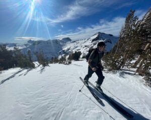
Striped 13,150′ and Vennacher Needle 12,995′ from Taboose Pass – 4 day tour
This year has been a record snowfall year. 900" at Mammoth Mountain. Over May 6-9, 2023, Dan from Mammoth and I went to explore Taboose Pass. Neither of us had been over the Crest in this specific area, or even up this trail. My perception for Taboose pass as a ski...
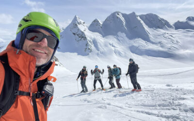
Sawtooths 3 day Loop – Finger – Whorl – Matterhorn 12,279′
First draft, excuse my late night first try at this. On April 14-16 2023 I had an insane experience touring through untracked wilderness with my new friend Javier. We met each other earlier this year by flying 40 miles north of Donald, near Golden BC, to ski tour for...
Tahoe Area
Mt. Price 9975′ – Crystal Range
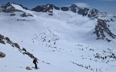
Mt. Price 9975' - Crystal Range Elevation Change from Glen Alpine Trailhead - 2700' and 12 miles Here are a few picture stories to try and sell you on going out to Mt. Price. This peak is the most northern summit of the Crystal Range, which borders the west side of...
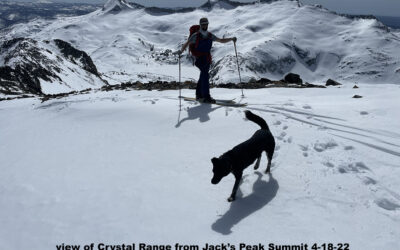
Jack’s Peak 9856′
Location: Desolation WildernessElevation: 9,856'Elevation Change: 3,500'Recommended Map: Desolation Wilderness - Tom Harrison or Lake Tahoe Southwest - Alpine Ski Tours Jack's Peak isn't skied often, which is exactly why you should go do it. You need to ski them all...
Mt. Tallac 9,735′
Location: South Shore - Lake Tahoe, CADuration: 2-3 hoursElevation Change: 3,200' - from 6,535' to 9,735'Recommended Map: Emerald Bay, California Elevation Profile: Map of General Route: I re-write my ski tour posts every time I look at them. Sorry, I'm torn between...
Jake’s Peak 9187′
ocation: West Shore - Lake Tahoe, CADuration: 1-2 hoursElevation Change: 2,357' - from 6,830' to 9,187Recommended Map: Emerald Bay, California Elevation Profile: Map of General Route: With some real sweat and skilled skinning, you can wind your way up to a nice view...
Rubicon Peak 9183′
Rubicon Peak 9183' Location: West Shore - Lake Tahoe, CADuration: 1-2 hoursElevation Change: 2,200' - from 6,800' to 9,000'Recommended Map: Rockbound Valley & Meeks Bay, California Elevation Profile: Map of General Route: A Tahoe classic, this is the peak...
Bliss Peak 9200′
Location: West Shore - Lake Tahoe, CADuration: 1.5-2 hoursElevation Change: 2,400' - from 6,600' to 9,000'Recommended Map: Emerald Bay, California & Rockbound Valley, California Map of General Route: Bliss Peak, also known as Hidden Peak, is the short tour Tahoe...
Volcanoes
South Sister 10,358′ – Oregon
South Sister 10,358' - Oregon Elevation change - 5500' You'll research a bit more than here to ski the Three Sisters Wilderness, I have only been in this area twice. These photos are from the late 90's when I skied a few Volcanos with Jamie Schectman, Steve Reynaud,...
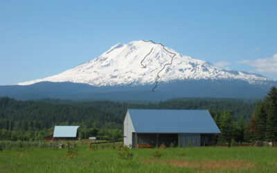
Mt. Adams 12,276′ – Oregon
Mt. Adams 12,276' - Oregon Elevation Change - 6600' I skied the popular southwest chute of Mt. Adams in June 2008 with Roger. We did it in a day and enjoyed the long fall line skiing right off the summit. This is a great peak. It's a little less steep than McLoughlin...
Mt. Jefferson 10,497′ – Oregon
Mt. Jefferson 10,497' - skiing is below 8500' Trailhead elevation 4100' The guidebooks I have at home are Oregon Descents by David Waag 1997, and Backcountryski Oregon by Christopher Van Tilburg 2001. You’ll also find some pics and home-made maps on an older website...
Eastern Sierra

Cirque Mountain 10,712′
Trailhead: Twin Lakes Campground - Bridgeport Summit Elevation: 10,712' Elevation Change: 3615' Gabe Metzger and I had fun on this obscure Hoover Wilderness Peak 1/26/26 in very low snow conditions. We were aiming for something new in this area and were forced into...

Mt. Lamarck 13,417′
Location: North lake Trailhead 9400'Elevation: 13,412'Elevation Change: 4012' This is a new post after skiing Mount Lamarck again on April 26, 2026. Previously I described a descent of the north couloir on the way back from Mt. Darwin. Check out that post too. We...

Seven Gables 13,080′
The seed for this tour started for me in 1994 when I got my hands on the Moynier High Sierra Skiing Guidebook. This peak wasn't in there, but I ticked all of them except one I believe passes the sketchy threshold for my age at this point. Then I moved over to the...

Leavitt Peak 11,569′ – Sonora Pass
Here are some pics from two separate outings. I aim for Leavitt Peak every year when Sonora Pass hwy 108 opens. Maybe I actually have got there 5 times and skied the same thing, the highest peak in a nice half day ski. I should go ski some neighboring terrain, but...
Striped 13,150′ and Vennacher Needle 12,995′ from Taboose Pass – 4 day tour
This year has been a record snowfall year. 900" at Mammoth Mountain. Over May 6-9, 2023, Dan from Mammoth and I went to explore Taboose Pass. Neither of us had been over the Crest in this specific area, or even up this trail. My perception for Taboose pass as a ski...
Sawtooths 3 day Loop – Finger – Whorl – Matterhorn 12,279′
First draft, excuse my late night first try at this. On April 14-16 2023 I had an insane experience touring through untracked wilderness with my new friend Javier. We met each other earlier this year by flying 40 miles north of Donald, near Golden BC, to ski tour for...