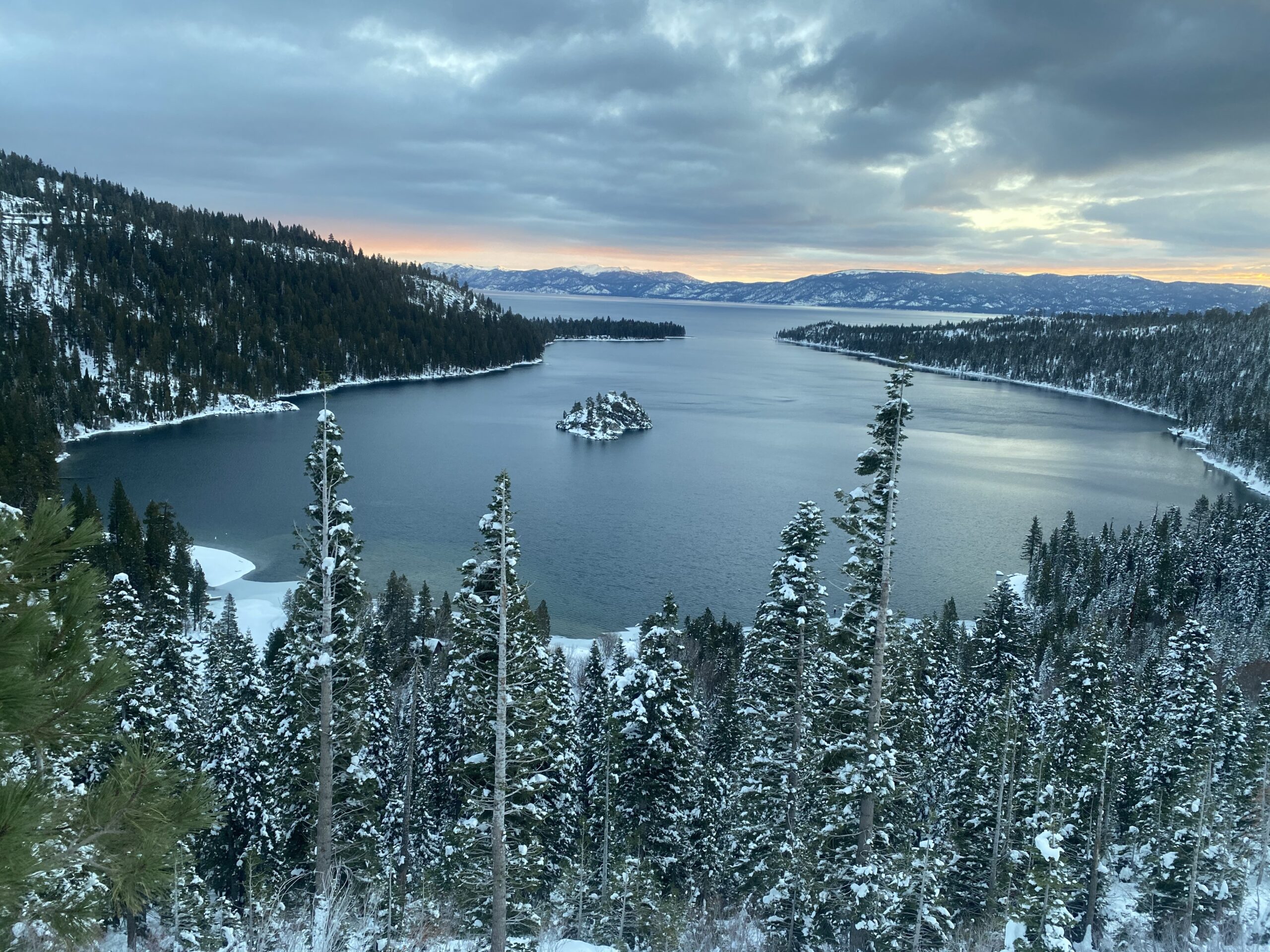
Location: Emerald Bay – Lake Tahoe, CA
Duration: 1 – 1.5 hours
Elevation Change: 1,822′ – from 6,837′ to 8,659′
Recomended Map: Emerald Bay, California & Rockbound Valley, California
Elevation Profile:

Map of General Route:
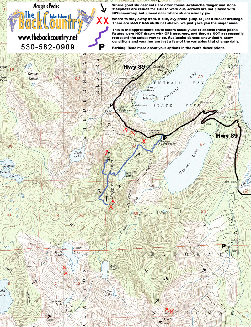
I’m not sure you need all this beta, I wrote a lot here. Look at the map while reading and maybe it will all make sense. I’m just saying all that I know for those who are interested. I do come here a lot.
Parking at Bayview Trailhead on hwy 89 is just above the south side of Emerald Bay. You do not need a Sno-Park Permit, and you are parking where Cal Trans clears an area to store their machine and turn around. There is a large, renovated summer parking lot right across the street, but it is gated in the winter. The bathrooms used to be left open in winter, I’m not sure now. Carpool as always, there are only a few spots to park. I have never heard of ticketing. Leave a note for CHP if you head into Deso overnight from here and don’t leave valuables in your cart. TRPA’s Lead Environmental Planner met me here 10 years ago and agreed this trailhead was important to preserve and improve for accessing Deso in the winter. They claimed there was a plan for adding parking area during a hwy 89 redo. Instead, they removed most of the parking area a few years later. They won’t respond to your comments or complaints about parking anywhere in the Basin but do it anyway. TRPA thinks we all belong at a ski area or in a State Park (which are all closed in the winter). Parking barely works right now so maybe just leave it until there is a problem. I don’t see more than a few groups skiing from here each day. But maybe it’s a zoo on weekends. If you can’t park here, continue just a few miles south to Mt. Tallac.
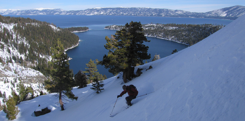
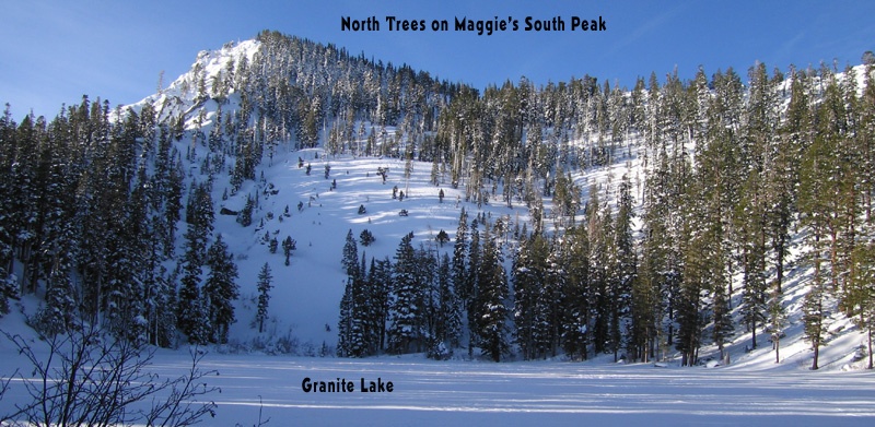
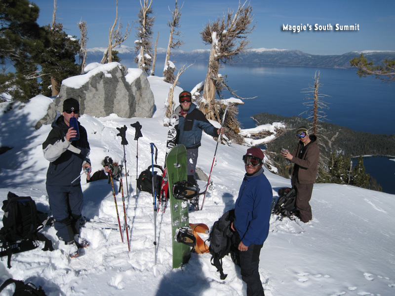
Maggie’s has two summits, split by the summer Bayview Trail. You will be skinning up the same route as the summer trail pretty much the whole way to the saddle between Maggie’s two peaklets. Leave the car and head into the campground, past a shut bathroom buliding. Keep going straight up through the trees to join a snow-covered road, which is the summer trail. This is sometimes the crux of the climb, as it can be crusty. Follow the snow-covered road until you join the creek which drains Granite Lake. Stay on the right side of the creek and lake and angle up to the gap between the peaks. Don’t go too far right or rocks will force you to come back down a little. I like playing a game where I make zero switchbacks between Crag Lake and the pass. You will probably need a few switchbacks near the top. You are skinning up a SE slope that gets crusty quick. Splitboard skinning is really tough. Just go further left into the more east facing and steeper slope, where you can switchback up in softer snow. You can access both north and south summits from saddle between the peaks. I’m calling it a pass at times, sorry to confuse you. it is a pass if you are headed west to other peaks. If you are headed for the North Maggie’s Peak, you might head right a little earlier, and wrap around below the summit to gain the peak on it’s east side. Climbing to the South Peaklet from the pass is low angle and straight forward. When you get up there, wander off to some boulders on the west end of the summit for the best view.
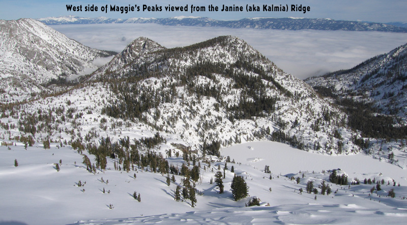
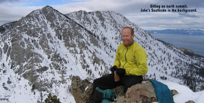
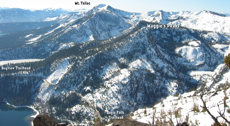
This is the same route out to the Kalmia Ridge and Dick’s Peak as well. Go up to both peaks. The South Peak gives you views to the West, spreading from Tallac all the way to Dick’s Peak. You can see the long kalmia ridge in the foreground, which is accessed by gliding down mellow terrain following the exact summer trail route. From North Maggie’s Peak you can see the long ridge of jake’s Peak’s South Side.
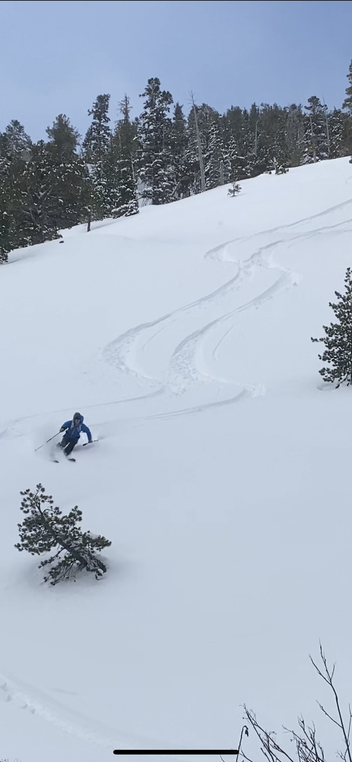
Maggie’s isn’t the most popular ski tour, because of a few reasons. The terrain you climb from Bayview Trailhead is a bit tightly treed for good skiing. In fact the lower 1/3 of the mountain is more a survival point and hockey stop type deal. The peak doesn’t look that impressive from the road at first, but it really is amazing when you learn all the lines to ski. And with Jake’s Peak or Mt. Tallac on either side, Maggie’s gets passed up. If you go with a local who really knows Maggie’s, you’ll be sold. Like Bliss Peak, the few small zones that are good for skiing, are really good. There are some very steep lines to ski as well as cruiser beginner terrain.
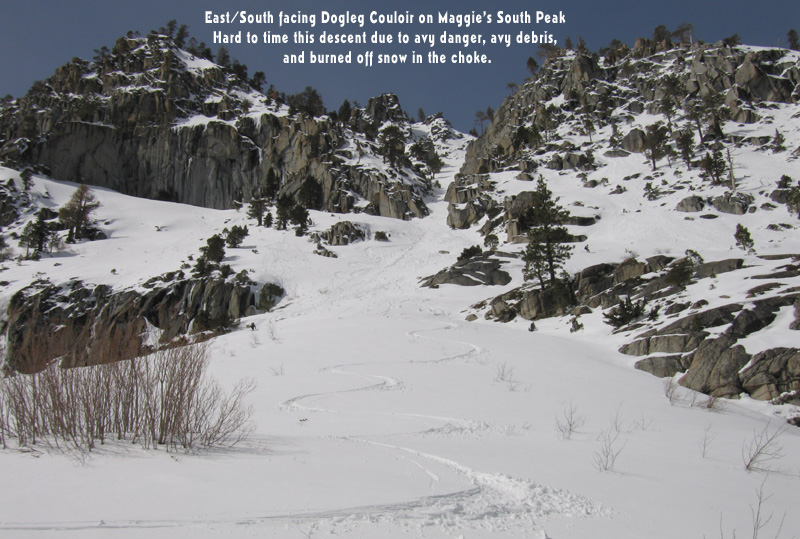
South Maggie’s South Side: I’ll start with the line you probably shouldn’t do. It’s known as the Dogleg, now also called Treth’s after a South Tahoe backcountry skier was killed in a slide there. The upper face is east facing and steep, and it’s hard to test the slope with a ski cut or snowpit without being on it. And you ski down over cliffs until you curve around a choke, where all the snow would go in a slide. Then you’ll probably ski through old slide rubble in the choke and hate it. It is exciting however, and can have great snow in the upper half. You can see it well from down below, so go check it out by skiing the North Trees of Tallac from the Maggie’s Peak Trailhead. In order to investigate the Dogleg run by first skiing Tallac’s north Tree run, you pop over into the Cascade Drainage from a spot near the car. Look at a map and find the summer trail which does this very thing. OK, enough of this run. If the snow is deep and safe, go for it. Then do a run on Tallac’s North Trees and come back out that little Cascade Drainage Trail to the Bayview Trailhead I was just talking about. Or drop the line and head UP the Cascade Drainage for run on the Tallac-Kalmia Ridge, above Snow Lake.
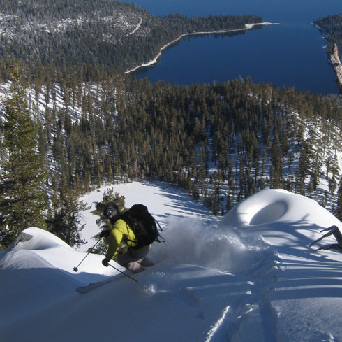
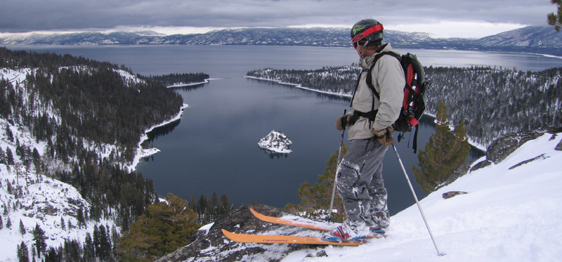
South Maggie’s NE side: This is a killer steep open glade run down to Granite Lake. There are small cliffs that are easily avoided, and you’ll want to know the avy danger before bombing this one. You can hunt around for the best snow as the slope offers subtle change of aspect. Stay skiers right for more north facing dry powder. Ski straight down and a bit left for a nice wide open treeless roll over slope above the lake. Or just aim back to the skin track where it is less steep.
North Maggie’s SE side: This is the slope above your skin track that gets a bit too much solar and starts to roller ball by noon. If you catch it immediately after a really cold storm, early in the morning, you might love it. To keep the snow colder and dryer on this peaklet, ski the true east ridge back towards the highway and remember to aim for the lower skin track. If you ski to far left you will miss the parking lot and ski a bit lower onto a nice steep slope above the highway. No biggie, walk back up the road.
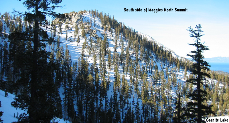
North Maggie’s North Side: This is the terrain you can see as you drive around Emerald bay from North to South. You’ll want a healthy snowpack to do this; like a few feet of snow sitting around down at Eagle Lake Trailhead. This 2000′ pow run has some route finding around many small cliffs, and it’s important to avoid skiing to the road anywhere other than landing at the creek and inner trailhead parking lot. When you finish at the creek, you can bushwack sidestep out of there to reach the highway in just a few minutes. That’s the spot you can finish your ski. You end up right at the creek. If you end up too far right on your descent above the roadside cliffs, put your skins back on and go up a little or sidestep/traverse. You’ll understand better when you drive around Emerald Bay and look at it. I usually ski This run after also skiing the NE slope on Maggie’s South. I car shuttle the half mile or just walk back alone without my gear to get the car. The top of this line requires that you commit to a narrow steep north facing chute that usually slides in the storm snow. Look for that evidence of thick avy debris in the chute. If you aren’t sure it’s safe, skip this line and just re-direct more East to re-enter the forest where you skinned up. If you do drop into the chute, feel out the rocks that get exposed during the first skier drop. Then traverse right below the chute and navigate to the creek I was just talking about. There are really nice small cliffs to jump off in this zone with the Emerald Bay scene behind you.
North Maggie’s North Bowl: This is a bit of work and confusing terrain when you go out first time, and you may not see any tracks. But that’s how you get untracked skiing…. you gotta head into the weird stuff that isn’t a gimmie. When I ski in this area, I usually don’t bother going to the summit of either peaklets. Start at Eagle Lake Trailhead if there is enough snow and follow the summer trail to Eagle Lake. Start angling uphill before you get to the lake and enter steep mature forest, and try to figure out the line that lets you climb through the cliffs. There is no way through the cliffs on left or middle. I go a bit right as I climb, and find a little ridge that has no rock exposed. Or you can just skin across Eagle Lake and keep going for a few minutes up the canyon, and take a left where possible up to the ridge. I usually find this little half pipe gully that works out great. At the top you’ll backtrack in an East direction and look for the weakness to ski through.
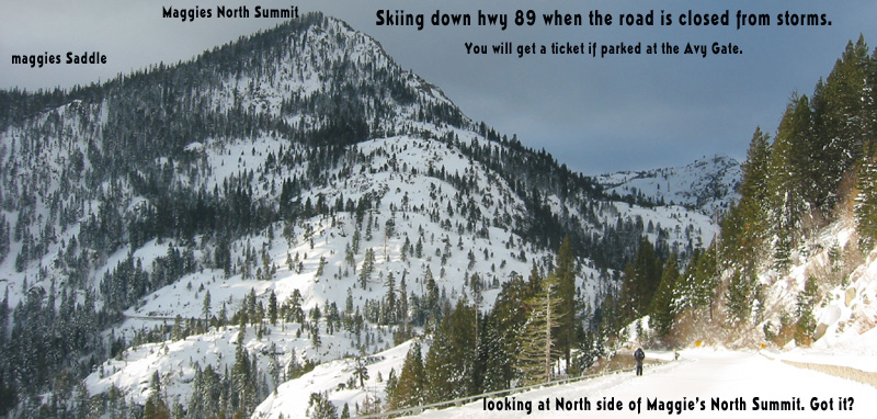
PRO TIP: When emerald Bay is closed, go crazy early for one of the coveted parking spots at the Emerald Bay avalanche gate turnaround on 89. Start with skins off, coast down the snow-covered road and skin up to the Bayview Trailhead. Now ski both of the Maggie’s Peaks’ north sides. It’s about a 4500′ day. Just ski the upper half of the south peak down to Granite Lake. then climb to the North Peak and weave down to the creek at Eagle Lake Trailhead. Again as I said above, avoid dropping the last bit to hwy 89, you’ll end up in cliffs. You must ski to the creek right at the inner parking lot. It’s a bushwack for a minute to get out to hwy 89 along the creek. Then skin back to the car. Boom. I just gave away my go to ski tour on powder day. And Carpool!!!

Looking for awesome ski and splitboard tours in the Sierras? We’ve got write ups on many common and uncommon tours curated by the owner of the BackCountry, Mike Schwartz.


Brought some friends out into Deso for their first tour and rented some gear from Backcountry. Turned around on Janines ridge and had some great corn boarding down the ridge and Maggies. All the friends are hooked now and want setups! Thanks for providing some good gear for our buddies.