
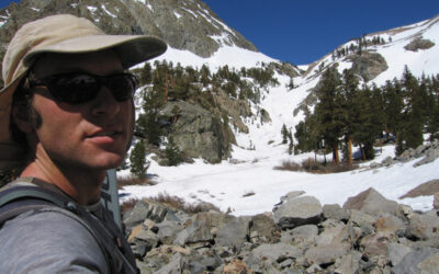
Hi, I’m Mike, and I started The BackCountry shop in 1994.
I want to thank you for helping us stay alive at our retail shop. You are supporting the families of over 30 employees as well as many local gear reps who we buy from.
This ski touring blog is in constant edit and add mode. I re-write nearly every time I look at my posts honestly. Check back regularly for improvements. Please don’t take anything I’ve said with 100% accuracy. My process is simply based on memory and looking at pictures I take. There is no precise measuring or complicated computer mapping going on here. I might start GPS tracking however with Gaia, replacing my old silly maps. Stop by the shop or contact me directly for help planning your ski tours. I am happy to direct you to the many local pro IFMGA guides as well.
There is an absurdity in trying to describe a backcountry ski tour. There is way too much to say if I were aiming to warn you of every danger and explain how to find the best experience. I buy every guidebook for ski touring and rock climbing, and rarely find I needed the few sentences I read. But they got me in the car and pointed me towards the best stuff in the area. My main goal is to get people stoked on ski touring while I tap at a keyboard at 3am, looking over old photos.
You can now add a comment with pictures and tell us about you day or recommend how I should edit my posts. I will read it all and I really appreciate your participation! I may not publish every comment. Think about contributing to stoke, beta, or laughter.

-
-
-
Grab a map and guidebook from our shop or here on the E-com website. Search the web for more beta. Talk to me. Hire an AMGA guide to teach you the skills. Put all that together and go for it!
-
-


-
There are inherent risks when skiing, snowboarding, snowshoeing or climbing in the backcountry. The routes on these maps may be dangerous and even deadly depending on many variables such as current avalanche danger, weather, snowpack depth, skill and experience level and time of day. Plan on climbing 1000 vertical feet per hour. Add time for low angle miles, high elevation, poor equipment and slow partners. Subtract time by starting early, traveling light, and strategic tour planning.
-
If you are not an expert and experienced backcountry skier, snowboarder, snowshoer or climber, we strongly suggest that you hire a professional guide. We recommend excellent local guides and backcountry skills classes from local pro guide companies International Alpine Guides and www.AlpenglowExpeditions.com. We also highly recommend Sierra Mountain Guides out of Bishop, and Shasta Mountain Guides if you are heading up there. There are a lot of competent Sierra ski guides. Skip the learning curve and help these guys make a living. Contact me for personal guide suggestions. But you can’t go wrong with AMGA certified guides.
-
-
You take FULL responsibility for yourself and your party when using this website for advice and the author disclaims any liability for injury or any other damage by anyone traveling in the areas described.
-
Please be patient if our guidebook recommendations end up being wrong for you – we don’t know you and your skill level and experience. We’re just showing you places where we enjoy the backcountry.
- CARPOOL CARPOOL CARPOOL. Park respectfully, bring a full-size shovel, be nice to Law Enforcement and Cal Trans Drivers. Join Tahoe Backcountry Alliance please. Complain to USFS, CA State Parks and TRPA for unwillingness to facilitate access to our public lands in Tahoe for decades. I have spoken to the top officials at “stakeholder” meetings and delivered private presentations on ski touring in Tahoe many times in the last 20 years. They say they are listening and agree…meanwhile they only remove parking and access every year. They don’t stick up for us. They claim they have no control over Caltrans and CHP. These land managers are equally charged with the duty of improving public recreation opportunities, compared to environmental protection. All they do is work on development and tourism. They will literally tell you that ski areas are where we should be going.
Have a great time and please be safe!
– Mike Schwartz
SAC is Sierra Avalanche Center and ESAC is Eastern Sierra Avalanche Center. Please donate to them on their website, they need the money, and you need the info.
Featured Tours
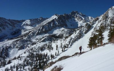
Mt. Goode 13,085′
Location: South Lake above Bishop, CAElevation: 13,085'Elevation Change: 3,317'Recommended Map: Bishop Pass - Tom Harrison The view of Mt. Goode from Long Lake is one you'll never forget, and quite easy to reach from your car. What you don't see is the HUGE south...
Mt. Sill 14,153′
Location: Palisades above Big Pine, CA Elevation: 14,153' Elevation Change: 5,900' Recommended Map: kings Canyon High Country - Tom Harrison Mt. Sill is the BIG guy you see from hwy 395 in Big Pine, CA. This 14er sits proud in the center of the infamous Palisade...
Kearsarge Peak 12,618′
Location: Independence, CAElevation: 12,618'Elevation Change: 3,433' up, 5000' downRecommended Map: Kings Canyon High Country - Tom Harrison Assessing conditions for skiing Kearsarge Peak is pretty easy, you can see most of the terrain from hwy 395. Although...
Tahoe Area
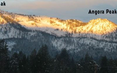
Angora Peak 8588′
CA Location: South Shore - Lake Tahoe, CADuration: 1 - 2 hoursElevation Change: 2,188' - from 6,400' to 8,588'Recomended Map: Desolation Wilderness Trail Map by Tom Harrison, USGS Topographic Map 7.5 Minute Series: Echo Lake, CA Elevation Profile: Map of General...
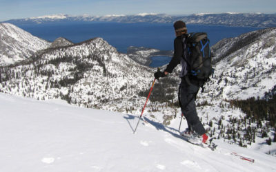
Dick’s Peak 9974′
'Location: Desolation Wilderness - Lake Tahoe, CADuration: 4 - 6 hoursElevation Change: 3,474' - from 6,500' to 9,974'Recomended Map: Desolation Wilderness Trail Map by Tom Harrison, USGS Topographic Map 7.5 Minute Series: Emerald Bay, California & Rockbound...
Rose Knob Jr. Peak 9600′
Location: Mt. Rose Wilderness - Lake Tahoe, NVDuration: 1.5-2 hoursElevation Change: 2,000' - from 7,600' to 9,600'Recomended Map: Mt. Rose, Nevada Elevation Profile: Map of General Route: Rose Knob Jr. is a quick ski tour for north shore locals who know you don’t...
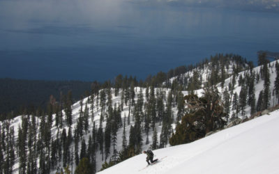
Maggie’s Peaks 8659′
Location: Emerald Bay - Lake Tahoe, CADuration: 1 - 1.5 hoursElevation Change: 1,822' - from 6,837' to 8,659'Recomended Map: Emerald Bay, California & Rockbound Valley, California Elevation Profile: Map of General Route: I'm not sure you need...
Castle Peak 9109′
Elevation Profile: Map of General Route: Castle Peak is popular due to easy access from Hwy 80, high elevation start, and mellow terrain. Get a CA Sno-Park permit at our shop ($5/day or $25/season) although as of dec 2022 we don't have them yet. I think Mountain...
Donner Peak 8019′
Elevation Profile: Map of General Route: Donner Peak is the sweet little mountain that dominates your view as you drive up old hwy 40 over Donner Pass. It is on your left above Donner Lake. Donner Peak is interesting, in that it offers extreme terrain on the north...
Volcanoes
No Results Found
The page you requested could not be found. Try refining your search, or use the navigation above to locate the post.
Eastern Sierra
Mt. Gould 13,000′
Mt. Gould 13,000’ Location - Onion Valley Trailhead above Independence, CA Elevation Change 3800’ I’m going to have to go back to this one soon. I’ve skied Mt. Gould a few times by myself. It’s a friendly east facing corn run to me that is skiable in late season. You...
Mt. Lyell – Tuolumne 13,114’
Mt. Lyell 13,114’ Elevation Change: 4400’ but 9-mile flat approach Location: Tuolumne Meadows On June 9, 2010 Eric Ongerth and I skied Mt. Lyell with a one-night stay, starting from the parking lot at Tuolumne Meadows Lodge and the John Muir Trail. Lyell is the...
Norman Clyde Couloir 13,000′
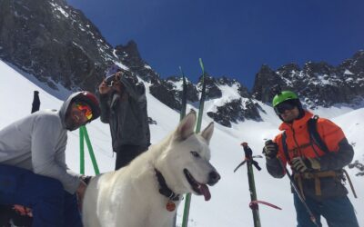
Norman Clyde Couloir 13,500’ – Middle Palisades Elevation Change: 5700’ These pics are from May 18, 2019. Ben Mitchell, Christian, Nick Bliss and his dog Owen all made it up to the top of Norman Clyde Couloir with me. This was a stellar day with blue skies and no...
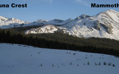
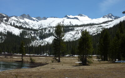
Mammoth Peak & Kuna Crest 12,112’
Mammoth Peak & Kuna Crest – Tuolumne: 12,112’ Elevation change: Not a ton, but some miles May 13, 2009 was a great solo overnight tour for me. There is a short window where Highway CA-120 gets plowed to the entrance of Tuolumne and they let you drive in to the...
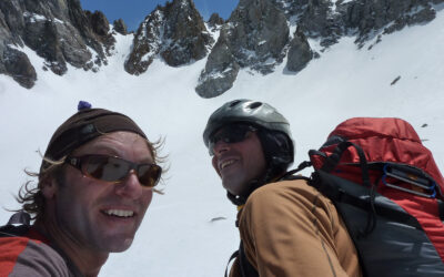
Mt. Bolton Brown 13,538′ & Balcony Peak 13,840′
Mount Bolton Brown: 13,538’Balcony Peak: 13,840’ Location: Big Pine Creek Trailhead 7800’ Map: The Palisades – Tom Harrison I have explained some other ski tours from Big Pine Creek Trailhead on this website like Kid and Slide Mountain, right above the car. Norman...
Buck Mountain 12,861′
Buck Mountain: 12,861’ Location: Big Pine, CA Elevation change: 5061’ Map: The Palisades Trail map – Tom Harrison The date on these photo files says February 18, 2008. This peak isn’t in the guidebooks and somewhere I heard it called Slide Mountain. Check it...